In the next three days, the temperature in the north will fluctuate obviously, and the rain and snow in the south will reduce the sunshine and return.
Cctv newsAccording to China Weather Network, in the next three days (February 25th to 27th), cold air will affect our country more frequently, but it can’t stop the general trend of warming up. The temperature fluctuates like riding a roller coaster, especially in the north, and the temperature fluctuation in some areas exceeds 10℃. In addition, since today, most of the rain and snow in the south have shrunk, and the sunshine in Jiangnan and other places has returned one after another, but there are still many rainy and snowy weather in the western region.
Cold air frequently disturbs temperature fluctuations and shocks, and the north-south trend is different.
After entering the "Eighth Nine-Year Plan", the main theme of China’s weather is warming up. However, the "warming road" is not always smooth. When winter and spring alternate, cold air activities are still frequent, and the temperature often fluctuates.

At present, there is a weak cold air that is affecting North China and Northeast China. There will be a new cold air coming tomorrow. The Central Meteorological Observatory predicts that from February 26th to March 1st, the temperature in Xinjiang, Northwest China, North China and Northeast China will drop by 4 ~ 8℃, and the local temperature drop will reach more than 10℃. Most of the above areas will have northerly winds of 4~6 and gusts of 7~9, and the wind in Shankou, Xinjiang will have 9~11 and gusts of 13. The cold air that will start tomorrow will have a wider impact, starting in Xinjiang on the 26th, in the northwest on the 27th and in the central and eastern regions on the 28th.
These two cold air streams have a more significant impact on the north. In North China, Northeast China, Huanghuai and other places, in the next few days, the temperature trend will mostly fall first, then rise and then fall. Most of the high temperatures occur from 26th to 28th, and the temperature in many places will hit a new high this year. By then, not only the highest temperatures in North China, Huanghuai and other places can reach 15 C, but also the highest temperatures in southeastern Inner Mongolia, Jilin and Liaoning will exceed 10 C.
In cities, such as Changchun and Shenyang, the highest temperature will reach 10℃ or above on the 27th, which is the first time this year to stand at the 10℃ mark. In cities with large temperature fluctuations, such as Lanzhou, the highest temperature can reach 16℃ on the 26th, and it will only be 7℃ on the 28th, and the cumulative cooling will be close to 10℃.
In the south, the influence of cold air is relatively small, and the temperature fluctuation is not as good as that in the north. In the next few days, the temperature will become a general trend. It is expected that by the end of February, the highest temperature in many places in the south of the Yangtze River will approach or reach 20℃, and the warmth will return. At the same time, the temperature difference between day and night will also widen, and the temperature difference in many places will be above 10℃. The public should still do a good job of cold protection and warmth when they leave early and return late.
From now on, the sunshine in Jiangnan and other places will return to the western region, and rain and snow are still frequent.
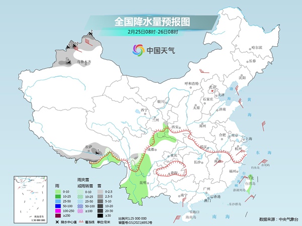
Yesterday, as the cold air gradually moved south, the rain and snow in the middle and lower reaches of the Yangtze River began to shrink. At the same time, there are also snowflakes falling in the Qinghai-Tibet Plateau and other places. Monitoring shows that from 08: 00 yesterday to 06: 00 today, there were small to medium snow or sleet in eastern Tibet, northwestern Sichuan, central and northern Shanxi, and heavy snow in Ganzi, Sichuan; Small to moderate rain occurred in southern Sichuan and southeastern Yunnan.
From today, the sunshine in Jiangnan and other places will return one after another; From 26th to 27th, there will be a wide range of sunny days in central and eastern China. However, in the western region, rain and snow still appear from time to time.
Today, there are small to medium snow or sleet in parts of northern Xinjiang, southern Sichuan Plateau, southeastern Gansu and southern Tibet. Among them, Tacheng, Altay and Ili Valley in northern Xinjiang have heavy snowstorms; There is light rain in parts of southeastern Tibet, southern Gansu, northeastern and southern Sichuan, and central and western Yunnan.
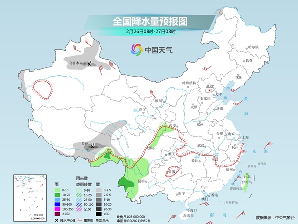
Tomorrow, there will be small to medium snow or sleet in parts of mountainous areas in northern Xinjiang and western southern Xinjiang, southeastern Gansu, eastern and southern Tibet, and southern Qinghai, among which there will be heavy snow in eastern Tibet and other places; There are small to moderate rains in parts of central and western Yunnan, northwestern Sichuan Basin and southeastern Tibet.
The day after tomorrow, there will be small to medium snow or sleet in parts of northeastern Inner Mongolia, northwestern Heilongjiang, southern and western mountainous areas of southern Xinjiang, eastern and northern Tibet, central and southern Qinghai, southern Gansu and western Sichuan Plateau, among which there will be heavy snow in parts of southeastern Tibet. Western and southern Sichuan Basin, western and northern Yunnan; There are small to moderate rains in parts of northern Guizhou and western Hubei.
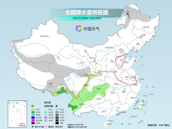
The meteorological department reminded that in the next three days, there will be intermittent rain and snow in eastern Tibet, Sichuan, Yunnan, Chongqing, Guizhou and other places, occasionally sunny or cloudy, and the sunshine will not stay long. The public should pay close attention to the approaching forecast and prepare rain gear when going out; In case of slippery and icy roads, you should drive slowly and pay attention to traffic safety.